CAOS · IISc Bangalore

Research Highlights

If last winter was La-Niña, this summer monsoon over India would reduce a bit

Normally, remote forcing (teleconnection) to Indian summer monsoon is quantified simultaneously — for example, connecting summer monsoon rainfall to summer El Niño–Southern Oscillation (ENSO) conditions. Can what happened in the past affect the present, through the slow evolution of the climate system?

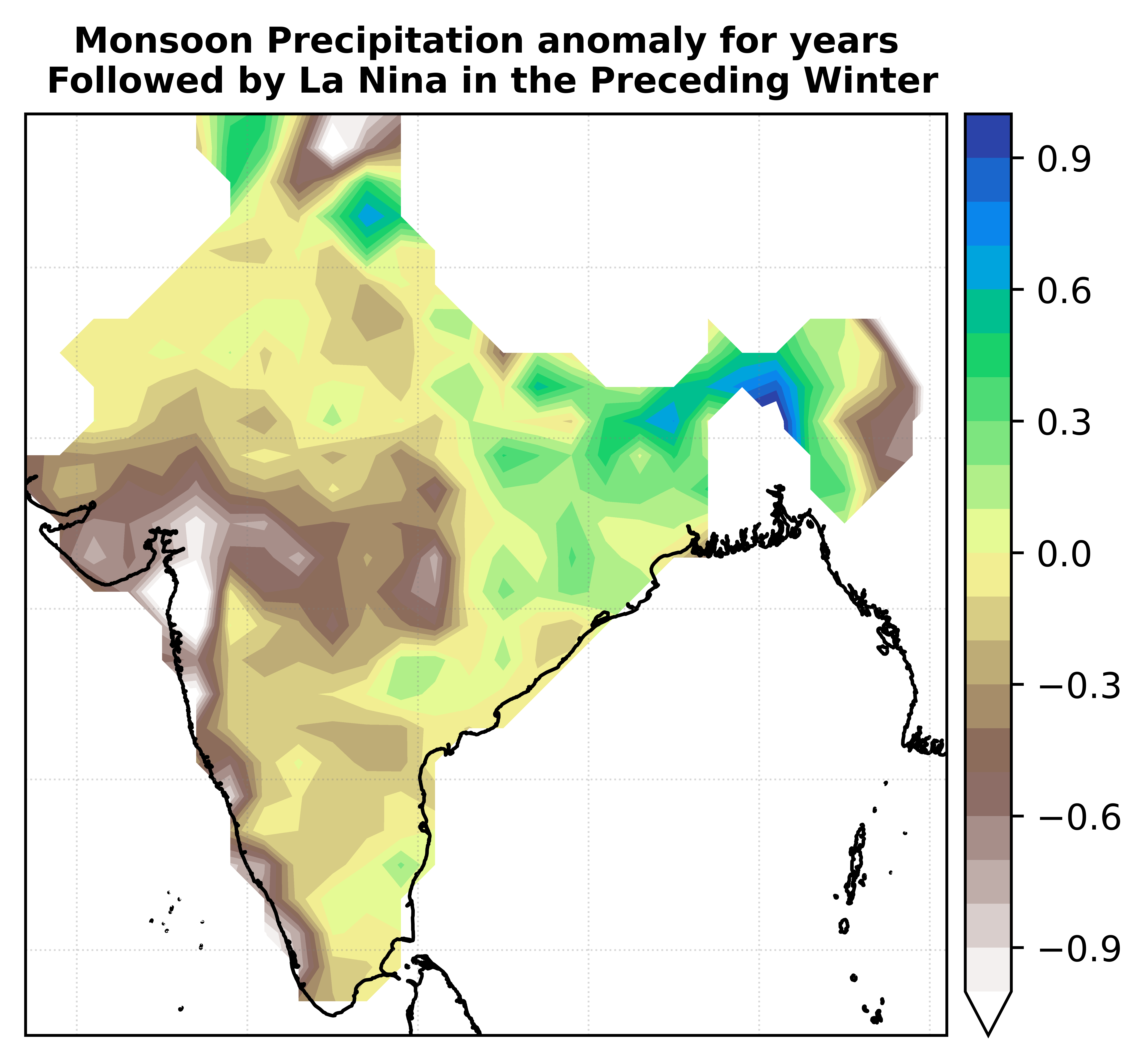
Using past data, we showed that if the previous winter was a La Niña, rainfall in the current summer over India would reduce a bit. In other words, a preceding winter La Niña increases the probability of a decrease in summer monsoon rainfall intensity. Even if the present summer is ENSO-neutral, mean rainfall over India is on average 4% below its long-term normal when preceded by La Niña. If the present summer is also El Niño, last winter's La Niña further increases the probability of drought — the first demonstration of this asymmetry between La Niña and El Niño of the past season on Indian summer monsoon rainfall. The delay in impact arises from the slow propagation of surface pressure anomalies in the subtropics as ENSO changes state with season.

References

  • Chakraborty (2018), link.
Precipitation Anomaly
Monsoon Precipitation anomaly (in mm/day) for years Followed by La Nina in the Preceding Winter.

Early and Late Onset of Indian Summer Monsoon Linked to West Asian Surface Pressure

The date of onset of the Indian summer monsoon shows substantial interannual variation. Monsoon onset isochrones gradually advance from the southern tip of India to the north and central regions, and then to the northwest. What determines the interannual variation of onset date over central India?

We show that in May — at least a month before onset over central India — surface pressure anomalies over West Asia are lower than normal in an early-onset year. Lower-than-normal surface pressure strengthens the cross-equatorial Somali Jet, bringing more moisture over Indian land. The increase in moisture decreases atmospheric stability and helps an early onset over both south and central India. Similar results are found in numerical experiments using a state-of-the-art general circulation model.

Such surface pressure anomalies propagate from west to east along the 20–30°N latitude band, at a speed equivalent to a mid-latitude Rossby wave — advancing the potential predictability of monsoon onset date.

References

  • Chakraborty and Agrawal (2017), link.
  • Chakraborty (2016), link.
Image / video placeholder

Connecting Extremes and Intraseasonal Oscillations of Seasonal Mean Monsoon Rainfall

The frequency of extreme rainfall events of the Indian summer monsoon has increased significantly over the past seven decades. At the same time, the variance of the low-frequency intraseasonal oscillation (LF-ISO) and the mean of the Indian summer monsoon rainfall decreased steadily. Are these contrasting changes physically connected?

In recent research, we found that an increase in extreme events during the break phase of the Indian summer monsoon can decrease its LF-ISO variance and seasonal mean — due to thermodynamic stabilization of the atmosphere and disorganization of large-scale circulation following an extreme rainfall event.

References

  • Karmakar et al. (2015), link.
  • Karmakar et al. (2016), link.
  • Karmakar et al. (2017), link.
Image / video placeholder

Seminar Series on Interannual to Decadal Variations and Prediction of Monsoon

We are organizing a seminar series on the variabilities of the boreal summer monsoon. We focus on the interannual to decadal variations of different characteristics of the summer monsoon over Asia in general and India in particular, intending to improve understanding and modeling.

The details can be found here.

Image / video placeholder